The tropical area has a large area of peatland, which is an important ecosystem that is regarded as home by millions of people, plants and animals. However, the dried-up and degraded peatland becomes extremely easy to burn, and in case of fire, it will further release transboundary haze.
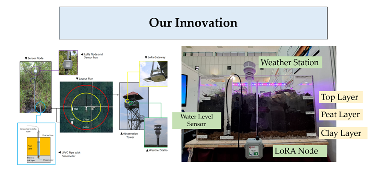
In order to protect the peatland, an improved tropical peatland fire weather index (FWI) system is proposed by combining the ground water level (GWL) with the drought code (DC). In this paper, LoRa based IoT system for peatland management and detection was deployed in Raja Musa Forest Reserve (RMFR) in Kuala Selangor, Malaysia. Then, feasibility of data collection by the IoT system was verified by comparing the correlation between the data obtained by the IoT system and the data from Malaysian Meteorological Department (METMalaysia).
An improved model was proposed to apply the ground water level (GWL) for Fire Weather Index (FWI) formulation in Fire Danger Rating System (FDRS). Specifically, Drought Code (DC) is formulated using GWL, instead of temperature and rain in the existing model. From the GWL aggregated from the IoT system, the parameter is predicted using machine learning based on a neural network.
The results results show that the Drought Code (DC) calculated from the IoT system has high correlation with the data released by METMAlaysia. This shows that DC can be calculated using predicted GWL. The Machine Learning prediction is essential for tropical peatland Fire Danger Rating System (FDRS). In turn, the innovation can be used to help predict and reduce the fire risk of tropical peatland.
Invention
The innovation is an IoT-based peatland management to complement the existing manual peatland data collection at Raja Musa Forest Reserve (RMFR), Kuala Selangor. The IoT system profiles ground and weather data for an early warning system based on Fire Danger Rating System (FDRS) indices, specifically the Drought Code (DC).
The uniqueness of this innovation is the use of Ground Water Level (GWL), which is profiled from the IoT system, to calculate DC, instead of temperature and rain as in used in the existing FDRS model. The new DC formulation is based on GWL predicted using Machine Learning technique, and it has shown good agreement with the ground truth DC values released by METMalaysia.
The innovation has helped complement and improve the existing peatland management at RMFR and reduce peatland forest fires which could lead to transboundary haze in ASEAN region.
Advantages
The innovation of IoT-based peatland management to complement and the exisiing manual data collection at RMFR Kuala Selangor has provided more timely peatland-related data collection.
The IoT system can collect ground water level (GWL), soil humidity and soil temperature every 2-minute interval and the data can be used for prediction of Drought Code (DC) in real-time using Machine Learning.
Market Potential
IoT service provider, Jabatan Perhutanan Negeri Selangor (JPNS), Jabatan Bomba dan Penyelamat Malaysia (JBPM), Jabatan Meteorologi Malaysia (METMalaysia)
TRL 6 – IoT deployment at RMFR, Kuala Selangor, Selangor, and ground data (i.e. ground water level) is profiled from the IoT system.
Prof. Ir. Dr. Aduwati Sali
Faculty of Engineering
aduwati@upm.edu.my
For commercialisation discussion, please contact us at promosi@upm.edu.my
Tarikh Input: 27/06/2023 | Kemaskini: 27/06/2023 | asrizam
PERKONGSIAN MEDIA